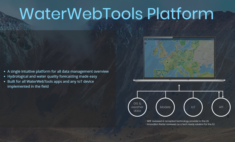
The WaterWebTools Platform serves as the overarching architecture for a host of our digital solutions allowing for maximum scalability, customization, and agility for client needs.
Our multi-source integration platform enable overlay of large environmental datasets with modelling, IoT, and weather data, and enables highly advanced forecasting and analysis at small to very large scales.
Our multi-source integration platform enable overlay of large environmental datasets with modelling, IoT, and weather data, and enables highly advanced forecasting and analysis at small to very large scales.
Full description
The WaterWebTools Portal supports a range of hydrological and water quality forecasting solutions, as well as advanced visualization and analysis of large environmental datasets on maps and dashboards - right within your own computer's webbrowser.
WaterITech offers onboarding and preprocessing of datasets for the WaterWebTools Portal, including any maps and data that can be displayed in the portals BGIS solution. BGIS is our Browser GIS solution, which allows visualization and postprocessing of large amounts of environmental data on the users own computer - simply using a webbrowser. The solution combines powerful map visualizations at local to global scale with advanced options for data processing and custom visualizations via dashboards.
WaterITech offers onboarding and preprocessing of datasets for the WaterWebTools Portal, including any maps and data that can be displayed in the portals BGIS solution. BGIS is our Browser GIS solution, which allows visualization and postprocessing of large amounts of environmental data on the users own computer - simply using a webbrowser. The solution combines powerful map visualizations at local to global scale with advanced options for data processing and custom visualizations via dashboards.
Value proposition
Why use the WaterWebTools Platform for disseminating environmental data in your projects? Well, just to mention three good reasons:
1. There is no point in reinventing the wheel. A lot of the interactive functionality typically desired by academic and private partners in R&D projects is already supported by the WaterWebTools Platform – and we are committed to continuously advancing the portal to even better match the needs and expectations.
2. Data produced in your project can live beyond the project's lifetime. Too many research projects develop data and digital tools, which dies once the project is completed. Therefore, a lot of time and resources are potentially wasted. Using us as a trusted partner, we can make sure that digital solutions and data will live beyond an individual project’s lifetime.
3. Get best-in-class data analysis and visualizations with ease. You can focus on what you are good at - producing awesome data, insights and science. You do not have to worry about developing a technical solution for disseminating your results to your own stakeholders and projects partners. We got your back. Guided by an informal an open communication with our clients, we can produce tailored map visualizations for individual projects within the WaterWebTools Portal. Feel free to reach out to learn more.
External links